Yellowstone Public Seismographs Taken Offline – Wait ’til You See Why!

The public seismographs which monitor earthquakes in and around the Yellowstone super-volcano are presently OFFLINE, and the public is not presently able to see seismic activity there.
Being able to see what is taking place in and around Yellowstone is of great interest to many people because if there is a sudden flurry of earthquake activity, it COULD — but not necessarily — signal a pending eruption.
Since Yellowstone is the only “super volcano” on the North American continent, and is VERY geologically active, if an eruption were to actually take place, the western two-thirds of the United States would POTENTIALLY be hit with volcanic ash and a severe disruption of life.
So why are the public seismographs from the US Geological Survey (USGS) OFFLINE (to the public) today? No one is providing any answers.
Even more peculiar, the privately-funded seismographs from the University of Utah . . . are also OFFLINE (to the public) right now. No one is providing any explanation for this either.
After poking around to various folks involved in the University of Utah Seismic Center, one person at that facility “quietly” e-mailed us a single graphic image which gave us pause:
In the image below, the Green Colored line represents the border of Yellowstone National Park. The (barely visible) gold line represents the mouth of the super-volcano, known as the Caldera. The red dots in the image below show all the earthquakes that have recently taken place at the Yellowstone super-volcano. Maybe this is why the public seismographs are suddenly OFFLINE to the general public?
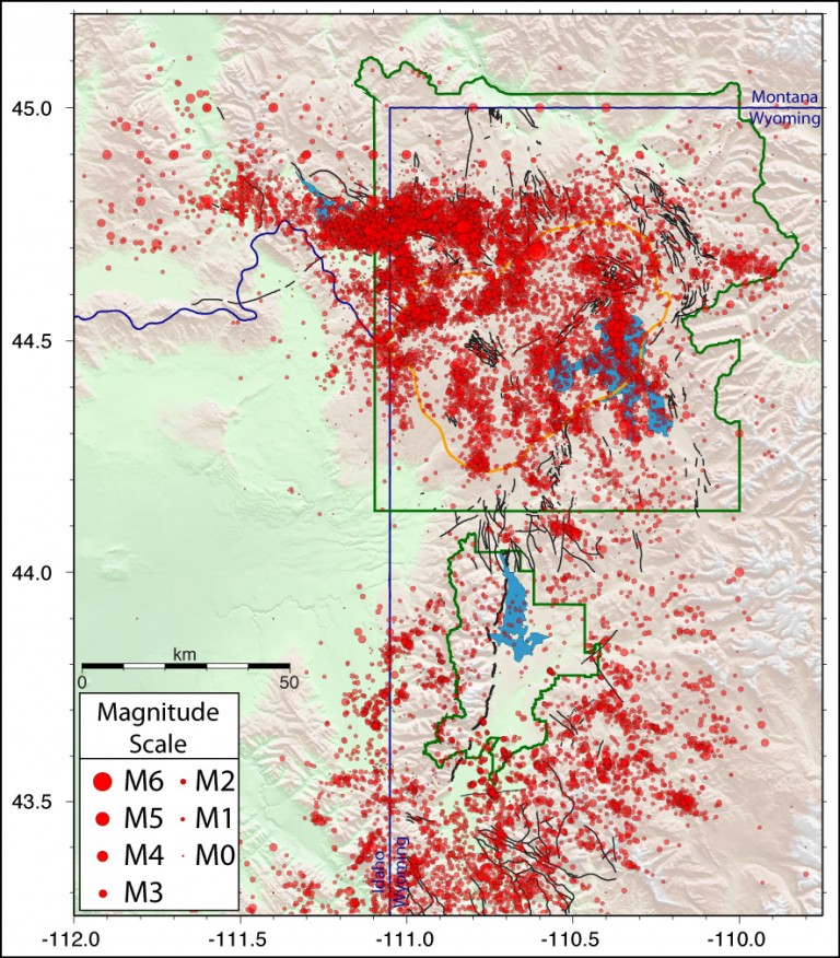
Courtesy: University of Utah Seismic Center
We are not seismologists, but it looks (to us) as though something is happening at Yellowstone. We’re seeking out professionals to interpret what we’re seeing and will update this story when that info becomes available.
In the meantime, as untrained laymen, the red dots in the image above tell us something “not good” seems to be taking place at Yellowstone.
THE BASIC FACTS OF YELLOWSTONE
Established on March 1, 1872, Yellowstone National Park is America’s first national park. The park was dedicated by President Ulysses S. Grant.
Yellowstone National Park was established 20 years before Montana, Idaho and Wyoming were granted statehood.Yellowstone National Park is 63 miles long and 54 miles wide.
Yellowstone National Park is larger than the states of Rhode Island and Delaware combined.
The Super-Volcano
Far beneath the ground in Yellowstone National Park, is something called a “Hot Spot.” It is a place where the molten core of the earth is closer to the surface than at other places.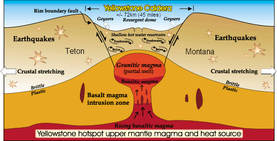
As the vast North American Continental Plate shifts over the years, different parts of the surface end-up being above the “hot spot.”
The image below shows the location of the “hot spot” over millions-of-years:
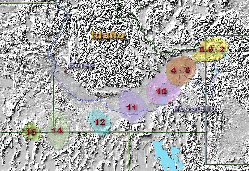
Location of Hot Spot expressed in MILLIONS-OF-YEARS
Geologists were able to pinpoint these locations by analyzing soil, where they found volcanic-related materials and melted rock buried under various layers of dirt.
ERUPTIONS
From time to time, the “hot-spot” bursts through the surface with an eruption. These are extremely RARE occurrences, which take place – on average – every 600,000 years or so. As of today, Geologists claim it has been about 640,000 years since the last big eruption, so by some standards, we may be a bit overdue.Volcanoes erupting is nothing new, but Yellowstone is not a typical volcano; it is a super-volcano. There are only thirty (30) super-volcanoes on earth and Yellowstone is the ONLY one on land. All the rest are beneath the oceans of the world.
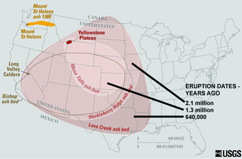
The image below explains the utterly terrifying difference between a “typical” volcano and Yellowstone.
At the top left of the USA map, the gold-colored area over Oregon, Washington and Idaho shows the famous “Mount St. Helens eruption” of 1980 and how far ash was ejected from that (typical) volcano.
Lower and to the right, shows the horrifying power of Yellowstone eruptions dating back as far as two+ million years (or so) ago. The ash covered two-thirds of the USA!
The ash is only a small part of the story. When Yellowstone erupts, there will be an enormous “kill zone.” Inside this “kill zone” nothing . . . . absolutely NOTHING . . . . will survive. The ash in this area is known as a pyroclastic flow. It will be so hot that anything it touches will be incinerated on contact. Humans, animals, trees, grass, cars, trucks, buildings. All destroyed immediately.
The next, even larger area, is called the “hot ash” zone. Most things in this area will be ignited by the hot ash and will burn. People, animals, cars, buildings. There will be so much fire and so much horror, that very little will survive.
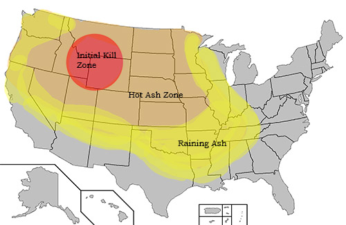
Beyond the Kill Zone and the Hot Ash Zone is the “raining ash zone.” In this area, volcanic ash with rain down for weeks! But what is commonly called “ash” is not really “ash” at all; it is pulverized ROCK. If a human inhales it, the rock turns into a mud-like substance in the lungs, suffocating the person to death.
The ash also clogs vehicle air filters, stalling vehicles because they cannot get air into the fuel injection systems. When stranded motorists exit their vehicles to see what’s wrong, they breath the ash, and that’s usually the end of them, too.
Anyone in the raining ash zone without a NIOSH filter mask rated at N-95 or N-100 will be dead in minutes; for lack of an $8 mask!
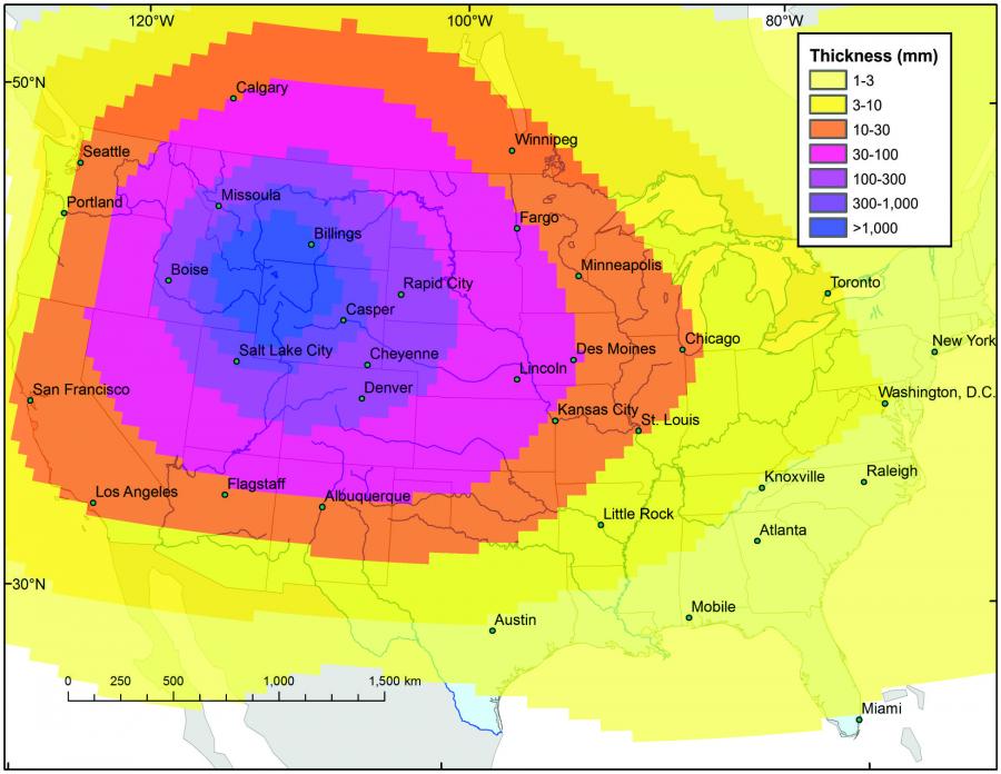
The image below shows how deep the ash is expected to be in various locations. Bear in mind that one inch equals 25.4 millimeters, click image to enlarge.
“Scare” in June, 2015
Yellowstone National Park was hastily evacuated in June, 2015 due to concerns that the super volcano could erupt sooner than expected. Researchers on-site claimed that the 640,000 year-old Yellowstone Caldera had exhibited a sudden spike in activity which indicated the volcano could erupt in as little as two weeks. They pointed out that an eruption of the volcano could very well throw all of United States into a 200-year-long volcanic winter, with ash blotting out the sun, and pyroclastic flow irreparably damaging the surrounding ecosystem.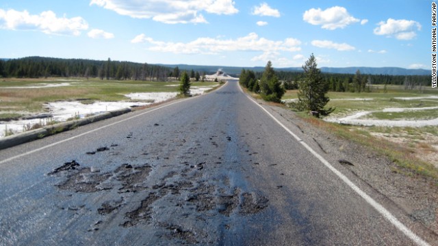
This undated photo provided by the National Park Service shows damage to a Yellowstone National Park road caused by the park???s ever-changing thermal features in the park in Wyoming. The hot, damaged pavement has prompted park officials to close Firehole Lake Drive and access to some geysers and thermal features at the height of summer tourist season. (AP Photo/Yellowstone National Park)
Also in 2015, several roads through Yellowstone were closed after
the pavement began to melt and bubble due to extreme temperatures rising
beneath the earth’s surface. No one has yet been able to pinpoint what
triggered this sudden surge of volcanic action. Officials monitoring the
volcano were primarily concerned with keeping curious thrill-seekers
out of the park, as well as safely vacating surrounding areas to prevent
potential casualties.
At the time Senior Volcanologist, Richard Dunn, gave the following
report in regards to the volcano’s alarming activity. “This is something
which could have never been accurately predicted ahead of time. This
unforeseen flux of activity is quite concerning, and flies in the face
of all our previous studies regarding this particular volcano. Our chief
concern at this point are getting people to safety.”
DO NOT PANIC; Just Be Aware
IT IS VITAL THAT YOU UNDERSTAND THERE IS NO OFFICIAL WARNING WHATSOEVER ABOUT ANY ERUPTION OR EVEN ANY PROBLEM AT YELLOWSTONE AND YOU SHOULD NOT TREAT THIS ARTICLE AS ANY TYPE OF WARNING.Related:
http://tradcatknight.blogspot.com/2015/08/planet-x-incoming-yellowstone-time-bomb.html
http://tradcatknight.blogspot.com/2016/02/planet-x-incoming-increased-volcanic.html